Perhaps the most anticipated part of our month-long journey was the opportunity to see penguins in the wild. Most tourists get on a boat and take a tour of the Beagle Channel which includes their boat pulling up on the shore of the penguin island and all of the tourist herding to the front of the boat to take pictures because they are not allowed to get off on the island. This did not sound like fun to us so we instead booked a tour where we could walk around the island and see the penguins up close.
We hopped on a bus on the morning of our second day in Ushuaia and took a windy 1.5 hour drive to the Estancia Harberton where our tour would begin. Along the way we stopped to check out some evidence of the harsh weather conditions that are the norm in Tierra del Fuego. The trees below are perfectly normal Southern Beech trees which had the bad fortune to be growing on the top of a ridge where they are exposed to extremely strong and consistent winds. The winds force them to grow almost parallel to the ground and for this they are called "Flag Trees" by the locals because they appear to be blowing in the wind.
The start of our tour, Estancia Harberton (Estancia roughly means ranch in English), is an interesting place for several reasons. First because it was established by one of the first missionaries (and therefore first foreign people) to settle in Tierra del Fuego and has remained in the Bridges family since 1886. The son of that original missionary, Lucas Bridges, was raised there and did a great job documenting and translating the language and history of the local Yamana people who were an extraordinary example of survival in an extreme climate with very few resources. The Estancia currently houses a small museum of local marine life and some researchers who monitor the local populations of whales, dolphins, penguins and other seagoing birds. Among the collection of things in the museum are skeletons of lots of different types of whales and penguins like the one below.
The researchers also have a "Bone House" where they are in the processes of removing the flesh and skin from the skeletons of various whales, porpoises, dolphins and whatever else they found. The smell in this house was quite interesting as you might imagine, but it was very cool to see the dirty work that goes into preparing all of the clean skeletons you see in museums. I'll spare you the pictures as they are a bit gruesome.
From there we took a walk across the grounds of the Estancia which contain the original buildings built by the Bridges family and hopped onto our little Zodiac to cross to the penguin island in the Beagle Channel.
There are two types of penguins on the island. The first type, of which there are only something like 24 mating pairs, is the Gentoo penguin. These penguins are the 3rd largest in the world behind the Emperor and King penguins and can grow to be up to 3 feet tall. Others of the Gentoo species do live as far south as Antarctica, however the ones we saw will probably never go their in their lifetimes.
The second type of penguin, of which there are thousands on the island, is called the Magellanic penguin. These penguins also never go to Antarctica, but rather migrate between the strait of Magellan (hence the name) and Brazil. They are rather small for penguins as they only get to the range of 2 or 2.5 feet tall.
All over the island the penguins had dug out their burrows as it was mating season. The males dig burrows and then the females choose males to mate with based on the size, location, and quality of their burrows more-so than the "beauty" or other characteristics of the males themselves. We had to walk on designated paths very slowly and carefully so we did not disturb the penguins or their nests. As you can see, they were quite used to their giant visitors and were not too scared of us.
Many of the penguins were in the process of molting during which time they must remain on the island for about 5 days without going into the water to feed while their old feathers fall off. We saw both juveniles (like the one being fed by its mother below) and adults going through the molting process.
You can tell the difference between the juveniles and adults by the coloration of their feathers.
It's hard to show with pictures just how cool this place was so I'll let the two videos below do some of the talking (along with the sound of the wind in both videos). The first video shows a good part of the area where we could walk and you can see both types of penguins with burrows in the area along with a territorial warning call to us from one of the Magellanic penguins.
The second video should give you some idea of the beauty of the Beagle Channel along with the number of penguins running all over the island.
Definitely one of the coolest experiences yet!
Sunday, February 27, 2011
Thursday, February 24, 2011
Fin del Mundo- Ushuaia and Tierra del Fuego
Ushuaia, Argentina. The end of the world. The southernmost city on Earth. Where mountains meet the Beagle Channel, there is this old port town suddenly transformed into a tourist hub and the embarkation spot for Antarctica cruises. As it was the end of our journey, we wanted to make sure we made the most of our time at the end of the world!
I believe I mentioned it has become a tourist town right? Well, the post above, stating how many kilometers Ushuaia is from other cities is a major picture-taking spot, a few blocks from the main tourist area. The picture below shows some of the mountains that were the backdrop.
The Argentine province where Ushuaia is located is called Tierra del Fuego- Land of Fires. It gets its name from Ferdinand Magellan, when he made his trip around the world. When Magellan sailed around the tip of South America, he saw small fires along the coast, therefore, Tierra del Fuego. When Darwin made his trip down to South America, he called the native peoples who lived here Fuegians. More on them in a later post.
There is a decent sized national park, Parque Nacional Tierra del Fuego, with part of the park in Argentina and part in Chile. Most of the park is off limits to visitors, however there are some hiking trails. Since we had hiked a lot already, we did some of the easy hikes and enjoyed the scenery.
The park had some amazing lakes and picturesque views for our picnic lunch. A very good use of time for one day in Tierra del Fuego!
Sunday, February 20, 2011
Torres del Paine
While in El Chalten and El Calafate we were closely monitoring a large bus strike that had shut down southern Chile. This was a concern to us because our next destination was the most popular and probably most spectacular national park in South America which happens to be located just across the Argentine border in Chile. Torres del Paine is quite well known for its hiking and gorgeous mountain scenery so we were very happy to hear that the strike ended in time for us to make our planned visit. You can see the park in a variety of ways but the most popular is the famous W circuit. I painted the W on the map below in yellow so you can see what I am talking about when I refer to what we did each day. The campsites we stayed at are identified with blue circles and labeled with which night we stayed there. The red circle represents the location where I took the video you will find later in this post.
As you can see if you click on and blow up the map above, the hike we did looks roughly like a W. The first day we got dropped off on the right side near the Refugio las Torres and hiked uphill to the Refugio Chileno to set up our tent for the night. This campsite was the worst one in the park with the tents all crowded onto a small flat spot in a valley that acted as a wind tunnel all night, but we decided to camp there anyway because it was looking rainy when we arrived and we wanted to get up early the next morning to see the sunrise on the Torres del Paine. You can see the Refugio in the picture below and the tents are located in the trees just to the left.
The morning of the 2nd day we woke up at 3:30, braved temperatures that were probably in the high 30's or low 40's and strong winds to hike 2.5 hours up to the Base of Las Torres (the right tip of the W on the map). When I say up I do mean up as the entire hike was uphill with the last hour being a scramble over boulders and a very steep incline. The mirador was very cold but absolutely worth it as the view with the sun rising and hitting the Torres was absolutely gorgeous!
After seeing the sunrise, we quickly hiked back downhill to get the blood flowing again and back to our campsite for some hot coffee made with our handy dandy little camp stove (a great investment on mornings like this!) before packing up and heading off toward our camp for day 2. This day would be the longest hike we would do in the park and since much of it was with our full packs weighing somewhere between 30 and 45 pounds it was a challenging day. On the map we went from where we were camped the first night up to the Base of Las Torres, back down to camp, and then all the way over to Refugio Cuernos near the middle of the W. Along the way we saw one lonely guanaco posing for us on the top of a hill...
some beautiful lakes,and Los Cuernos del Paine (the Horns of Paine). The entire Paine Massif (basically the group of mountains making up the park) are not a full part of the Andes, but rather were formed by some magma that hardened underground into granite and then was pushed above ground due to the uplift that created the rest of the Andes. This is part of why the park is so cool, since there are combinations of different types of rock here that you just don't see very often.
The Cuernos above are mostly granite (the white parts at the bottom) with the tops being made of sedimentary rock (the black parts at the top). The granite was the magma that hardened under the sedimentary rock and was then pushed up. Pretty cool looking right!
The 3rd day we woke up, packed up, and hiked from Refugio Cuernos to the Camp Site Italiano where we quickly set up our tents and dropped our big packs. We then continued on up past Camp Site Britanico to a mirador (lookout point) in the Valle del Frances. While the Torres were gorgeous, this was probably the most beautiful day of our trip as we got to see glaciers, rushing rivers, and a wide variety of different types of mountains. About halfway up the climb, Jenna decided she wanted a jumping photo and proceeded to jump higher than she ever has in her life for this picture!
A little later I took this video (location marked with a red circle on the map) to show the incredible view from this point!
I can't really do justice photographically to the view from the mirador as it was in a glacial valley almost entirely surrounded by mountains but here are a few pictures that show some of it.
The next morning we packed up and headed down toward the Refugio Paine Grande with intentions of hiking with the tents all the way up to Refugio Grey. Unfortunately we got some rain and decided to hide out in the tents at the Paine Grande for the rest of the day. Our fifth day in the park we did a day hike up to Refugio Grey and the Grey Glacier instead. The glacier was beautiful but really not more impressive than the Perrito Moreno glacier so I'll skip the pics of the glacier itself and instead show you me enjoying some crisp, cold, refreshing glacier water,
Amy, Jenna and I posing by an iceberg,
and an incredibly blue iceberg floating in Grey Lake.
We then returned back to the camp at Refugio Paine Grande for some nice showers and beers to enjoy our last night in the park.
As you can see from the picture above, the park was quite popular (Can you find our tent in the picture?) and crowded. This was annoying at times but actually quite interesting because the 3 of us agreed that we had never been somewhere so international in our lives. Every group that we passed on the trails seemed to be speaking a different language, most of which we didn't recognize at all. It certainly made the approximately 75 km (near 47 miles) we walked over the 5 days more interesting!
The last morning we hopped on a boat and crossed Lago Pehoe to catch our bus out of the park. While waiting for our bus back to El Calafate near the Guarderia Laguna Amarga we got one final treat as we saw 7 condors soaring over a mountain searching for food at the same time. Great way to finish our time in the park!
Thursday, February 17, 2011
Perrito Moreno Glacier
After leaving El Chalten we finished our journey down Ruta 40 to the town of El Calafate. The town is named for a berry that grows in Patagonia (seen in the picture below). Legend has it that if you eat some of these berries, you will one day return to Patagonia so we had to eat a few. They were actually not bad and had a flavor kind of like blueberries!
The town of El Calafate itself is not all that spectacular, but it is still a huge tourist town because it serves as a base (with an airport) to travel to a lot of attractions in southern Patagonia. We used it to hit 2 of the most famous: Torres del Paine (details coming in our next post) and the Perrito Moreno glacier.
The glacier is one of the most accessible in the world and is also one of the only glaciers that still advances and retreats seasonally and is not losing mass overall. The glacier is not as old as many in Europe or other places because it flows quite quickly, by glacial standards, due to the slope of the ground it flows down. The ice in the glacier is only a few hundred years old compared to a few thousand or even a few hundred thousand for other glaciers around the world. The young age of the glacier clearly didn't take away from it's beauty which we first observed from the maze of observation decks near the glacier. Unfortunately we didn't get to see any large pieces break off and fall into the water (called "calving") while walking around the decks.
The accessibility of the glacier gave us the unique opportunity to join a tour, strap on some crampons, and walk on the glacier, So we hopped onto a boat (like the one in the picture below) and crossed the lake to go for our adventure. We first walked along the south edge of the glacier for about an hour and a half before stopping to put the crampons on and hit the ice.
Jenna was clearly very excited by this opportunity...
We walked for about 4 hours out on the glacier and unfortunately it got a bit rainy and overcast so I wasn't able to take too many pictures but it was a really fun experience. I kind of want to go buy some crampons for recreational use!
Near the end of the hike the guides planted their crampons near the edge of a moulin (sort of a hole in the glacier caused by warm melted water flowing downward) and let us take a look over while hanging on to our climbing harnesses so we didn't plummet to our deaths. The picture doesn't quite do the moulin justice but you get the idea.
Being the science nerd that I am, I couldn't help being fascinated by the glacier overall. I had expected the surface to be much smoother than it turned out to be (I guess this was my expectation having grown up playing on ice in Wisconsin which is very smooth and slippery) but it was actually quite rough from all the small areas of melted water that had formed, frozen, reformed, refrozen, etc. You can kind of see this from the pictures of the crampons above. The most interesting thing however was the color of the ice. Due to the immense weight of the ice, air bubbles are squeezed out of the buried ice. This gives the glacial ice a different color than normal ice from your freezer since the lack of air bubbles makes the light refract differently as it passes through. The fewer air bubbles in the ice, the deeper blue it looks as you can see from the pictures of the crevasse and hole below.
On our way back out to the boat we got to see the other tour group (that only got a short walk on the glacier) and got a little perspective on how immense the glacier is.
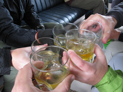
The tour company had one final surprise for us on the boat ride back... whiskey with glacier ice in it! Cheers to a fun day!
See the banner at the top of the blog for a panoramic shot of the glacier.
Subscribe to:
Posts (Atom)