Showing posts with label Patagonia. Show all posts
Thursday, March 3, 2011
Sailing!!!
As a culminating activity for our trip, we decided to do something neither one of us has ever done before- sailing! All we've ever heard about the end of the world, the Beagle Channel, we wanted to get on the water, and since those big touristy boats aren't really our style, this is what we decided. Once we got out on the water, the view of Ushuaia was amazing!
The boat only had space for 10 tourists, so our little group of five had half the boat. Part of the trip through the channel was getting close to the sea lion island so that we can take a look. We have seen sea lions before in the wild, but never in these numbers!

Even though it was summer, Ushuaia tops out around 50, 55. On the water, there was wind. And splashes of icy water. Despite bundling up, it was cold!!!
The main attraction of our journey through the channel was a trip to H island. This tour company is the only company with permission to land and take tours on the island. The island is the nesting ground for cormorant birds. Here's our trusty vessel.
Here, we are walking on one part of the H, with the other side there.

Cormorant colony! The cormorants use this island to create their nests, which are made out of their poop. The smell was a little overpowering as we neared the colony, but it was pretty amazing to see all the birds.
The Yamana people used this island as a resting area from bad weather, or to spend the night during fishing trips. The Yamana lived on the southern tip of the continent. The Yamana were very interesting because of their lifestyle and how they adapted to life in these extreme conditions. One, they didn't wear any clothes. They covered themselves in animal grease, which prevented body heat from escaping. Since they spend much of their lives in their canoes, they were in a huddled position. Therefore, there was less surface area in contact with the wind. Women were divers for clams and mussels. Since they didn't have any clothes, they were able to quickly raise their body temperature after contact with the 48-50F degree water. They kept warm by constantly having small fires around them, even in their canoes. The name of this region, Tierra del Fuego, is from Magellan spotting their fires.
It was cold, but absolutely beautiful and a wonderful way to end our trip. After we got off the boat, we thawed out with chai lattes, something was quite a treat!
Thursday, February 24, 2011
Fin del Mundo- Ushuaia and Tierra del Fuego
Ushuaia, Argentina. The end of the world. The southernmost city on Earth. Where mountains meet the Beagle Channel, there is this old port town suddenly transformed into a tourist hub and the embarkation spot for Antarctica cruises. As it was the end of our journey, we wanted to make sure we made the most of our time at the end of the world!
I believe I mentioned it has become a tourist town right? Well, the post above, stating how many kilometers Ushuaia is from other cities is a major picture-taking spot, a few blocks from the main tourist area. The picture below shows some of the mountains that were the backdrop.
The Argentine province where Ushuaia is located is called Tierra del Fuego- Land of Fires. It gets its name from Ferdinand Magellan, when he made his trip around the world. When Magellan sailed around the tip of South America, he saw small fires along the coast, therefore, Tierra del Fuego. When Darwin made his trip down to South America, he called the native peoples who lived here Fuegians. More on them in a later post.
There is a decent sized national park, Parque Nacional Tierra del Fuego, with part of the park in Argentina and part in Chile. Most of the park is off limits to visitors, however there are some hiking trails. Since we had hiked a lot already, we did some of the easy hikes and enjoyed the scenery.


The park had some amazing lakes and picturesque views for our picnic lunch. A very good use of time for one day in Tierra del Fuego!
Sunday, February 13, 2011
El Chalten
The town of El Chalten was founded in 1985, when Argentina and Chile were fighting over land. The year round population is around 600, and the ATM is less than a year old. It is also known as the hiking capital of Argentina because of the Fitz Roy range in the Parque Nacional Los Glaciares (Glacier National Park). The park has quite a few glaciers and is divided into two sections, the northern section, and the southern. While we were in El Chalten, we were hiking in the northern part.
The great part about the town is that the trail heads for the hikes start from town. No need to drive or hike a long ways to get to where the trail starts. We did two hikes total in El Chalten, camped up on a mountain in a the park, were stuck in our tent for almost two days straight with rain and wind, almost were knocked off bridges trying to get back to our tent with the 70+ mph winds, but had some amazing views! The first hike we did was about 8 hours, with 2 1/2 hours of ascent of 800 meters.
Along the trail we saw one of the glaciers... it just seemed to pop out of nowhere!
Then we started to see where we were going... Cerro Torre and Cerro Fitz Roy. This is only part of the range... Cerro Torre eluded us the whole time we were there. The clouds just would not depart!
At the top of the hike, were two glacier fed lakes, Laguna de los Tres and Laguna Sucia (literally dirty lake; the water was green from the glacier melt). It was the best tasting water I've ever had, and after a difficult ascent, it was amazingly peaceful.


The view of the valley and how far we'd come was breathtaking!


The peaks we were trying to see the whole time we were there. Finally, on our last day, the clouds lifted a bit so we could see them. We couldn't finish our second hike due to weather (rain and the crazy wind).
I have never experienced such extreme weather conditions like there were on the trails and in the campground in El Chalten. Even with the cloud cover and awful weather, the views were still spectacular. I can't imagine how beautiful and breathtaking it would be on a clear day.
The great part about the town is that the trail heads for the hikes start from town. No need to drive or hike a long ways to get to where the trail starts. We did two hikes total in El Chalten, camped up on a mountain in a the park, were stuck in our tent for almost two days straight with rain and wind, almost were knocked off bridges trying to get back to our tent with the 70+ mph winds, but had some amazing views! The first hike we did was about 8 hours, with 2 1/2 hours of ascent of 800 meters.
I have never experienced such extreme weather conditions like there were on the trails and in the campground in El Chalten. Even with the cloud cover and awful weather, the views were still spectacular. I can't imagine how beautiful and breathtaking it would be on a clear day.
Tuesday, February 8, 2011
Ruta 40
Part of the adventure of traveling is figuring out how to get from Point A to Point B. On our latest vacation, it involved the Ruta 40. It has been said that it is one of the world's greatest, yet most desolate stretches of road. It is Argentina's longest road; 3,107 miles long, passing through 11 provinces, 18 rivers, and only half of it is paved. Outside of South American travel gurus and Che Guevara fans, most people have never heard of it.
It is desolate. And it is windy. Really, really windy. The yellow landscape you see below is what we saw, almost all we saw, for two 12-hour days riding on a bus. Oh, and we did see some guanacos (same family as the llama) every once in a while.


This was close to the end of Day 1, when the pavement ended, and the dirt road began. The bus company we went with divided the trip into two days, with a night spent in a small, incredibly windy town called Perito Moreno. The town was ridiculously small; we were wondering what in the world the people who live there could possibly do for a living. Almost all of day two was on gravel, with a dusty bus, whose windows were not exactly sealed well, without a bathroom in the back. Some of the "bathroom stops" did not actually involve bathrooms but a few bushes and trees to block the wind.
It was two days of seeing a lot of the same (we also did a tour the morning of day 2, which Jesse will talk about in a later post). The Ruta made me appreciative for the modern highway systems of North America, but at the same time, a bit nostalgic for all the adventure left behind when we modernize, change, and transform classic, ancient journeys and turn them into efficient, tourist machines. I'd like to go back 40 years and travel along la cuarenta back then; it must have been the most desolate stretch of road imaginable, the type of road that makes you do a little soul-searching.
If you would like more information on the ruta 40, the following websites have some info.
The first link has one journalist's trip along la cuarenta, although he did not travel the same section that we did. His journey was a little bit easier!
http://www.travelandleisure.com/articles/andean-highs
And if you are interested in factual information, wikipedia site
http://en.wikipedia.org/wiki/National_Route_40_%28Argentina%29
Finally, one last person's experience on the road; he writes a bit more eloquently than I.
http://www.brendansadventures.com/ruta-che/
It is desolate. And it is windy. Really, really windy. The yellow landscape you see below is what we saw, almost all we saw, for two 12-hour days riding on a bus. Oh, and we did see some guanacos (same family as the llama) every once in a while.
It was two days of seeing a lot of the same (we also did a tour the morning of day 2, which Jesse will talk about in a later post). The Ruta made me appreciative for the modern highway systems of North America, but at the same time, a bit nostalgic for all the adventure left behind when we modernize, change, and transform classic, ancient journeys and turn them into efficient, tourist machines. I'd like to go back 40 years and travel along la cuarenta back then; it must have been the most desolate stretch of road imaginable, the type of road that makes you do a little soul-searching.
If you would like more information on the ruta 40, the following websites have some info.
The first link has one journalist's trip along la cuarenta, although he did not travel the same section that we did. His journey was a little bit easier!
http://www.travelandleisure.com/articles/andean-highs
And if you are interested in factual information, wikipedia site
http://en.wikipedia.org/wiki/National_Route_40_%28Argentina%29
Finally, one last person's experience on the road; he writes a bit more eloquently than I.
http://www.brendansadventures.com/ruta-che/
Sunday, February 6, 2011
Bariloche, Argentina
Due to all the travel issues we had over Christmas, our vacation plans changed a bit. We were planning on having two days in Bariloche, but since we weren't going to northern Chile or the Salt Flats, we decided to spend a few more days in Bariloche. Bariloche is right along the Andes mountains, next to Nahuel Huapi Lake.


The main, government buildings downtown were all designed in the 1930's with a Swiss-German architecture feel.
We rode the teleferico (gondola) up the side of the mountain to get a good view of the city.
Bariloche is known throughout South America as having good chocolate. I mean, chocolate shops were everywhere! We asked a taxi driver for his favorite place, and he said Mamuschka. So we went there. Twice. The bonbones (filled chocolates) were amazing. I wasn't all that impressed with the plain chocolate, but the ones filled with dulce de leche, mousse, coffee, almonds; they were amazing.
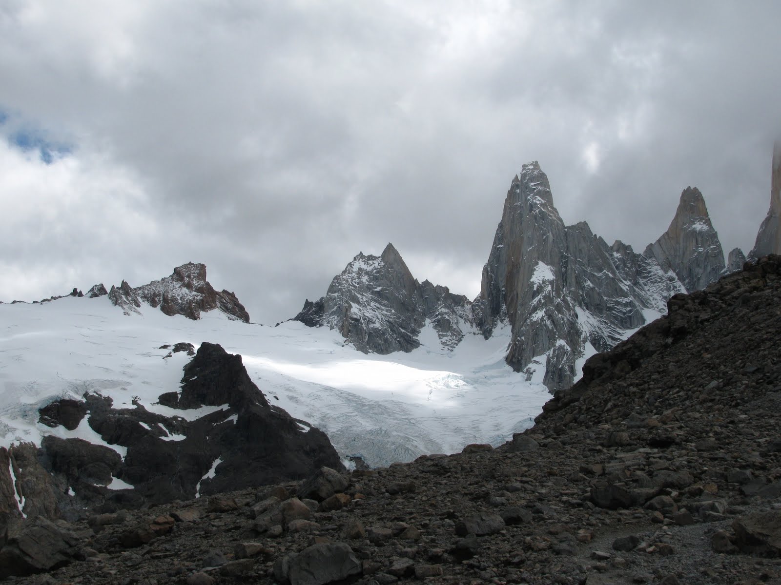
We went on one day hike before our friend Amy and her sister and brother-in-law arrived. It was an 8 hour hike, around 20 kilometers, with about almost 2 hours of ascent on the Cerro Catedral. The Cerro is the main ski mountain for the area in the winter. The hike was difficult, and this being our first hike in awhile made it even more difficult. For the last 20 minutes we were climbing over boulders. Our knees and feet were killing us by the time we got back, but, there were some beautiful views that you just couldn't get from anywhere else.
There was a whole area of burnt trees, from a forest fire, and they led themselves to some beautiful photos.
What was interesting about this hike also were the rock formations of the mountains.


This was the refuge at the top of the hike. If we had wanted, we could have brought up our tent and spent the night there.
We went on one other small day hike when our travel buddies arrived. This one was in the national park, by all these small lakes and lagoons.

On our last night in Bariloche, we went out to eat, at this hobbit house looking restaurant, completely built with local, Patagonian wood. I wish I would have brought my camera to take a picture of our meal. It was probably the best steak and lamb I've ever had. And the dessert, the chocolate spell,... well, it was devoured in minutes!
We rode the teleferico (gondola) up the side of the mountain to get a good view of the city.
We went on one other small day hike when our travel buddies arrived. This one was in the national park, by all these small lakes and lagoons.
Subscribe to:
Posts (Atom)